The Manaslu Circuit Trek is universally acknowledged by high-altitude mountaineers and professional trekking guides as one of the most structurally rewarding long-distance Himalayan trails within the borders of Nepal. Encircling Mount Manaslu—which stands as the eighth-highest mountain in the world at an imposing 8,163 meters (26,781 feet)—the route traverses a highly restricted ecological and international border zone. This geography is characterized by exceptionally deep river gorges carved by glacial meltwater, vast alpine high-altitude deserts that mimic the Tibetan plateau, and deeply entrenched Tibetan-Buddhist cultural enclaves that have remained isolated from rapid modern development. Unlike the heavily commercialized and structurally saturated corridors of the Everest Base Camp and Annapurna Circuit trails, the Manaslu region enforces strict permit limitations that preserve its raw, undisturbed ecological balance and limit crowd density.
The geographic progression of the Manaslu Circuit dictates a steady, demanding ascent through the Budhi Gandaki River gorge. The trek initiates in subtropical, Hindu-dominated foothills characterized by heavy humidity and terraced agriculture. As the altitude systematically increases, the ecological and cultural environments shift proportionately. By the time trekkers arrive at the village of Samagaon at 3,530 meters, the landscape is unequivocally defined by traditional stone-and-timber settlements, vast yak pastures, and meticulously hand-carved mani walls. It is from Samagaon that the essential side trek to Pungyen Gompa begins, offering a critical physiological acclimatization stimulus before the final, oxygen-deprived push toward the high alpine pass.
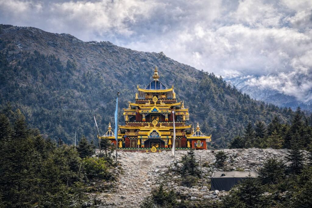
Nestled deep within this rugged topography lies Pungyen Gompa, an ancient, active Buddhist monastery perched at an elevation of approximately 4,000 meters (13,123 feet). Positioned on a vast, windswept plateau directly beneath the towering eastern face of the Manaslu massif, the monastery serves as a vital spiritual epicenter for the local Nubri and Tsum populations. Within the context of the greater 170-kilometer Manaslu Circuit, the detour to Pungyen Gompa is frequently overshadowed by the physiological necessity of preparing for the 5,106-meter Larkya La Pass crossing. However, bypassing this sanctuary constitutes a severe omission. Pungyen Gompa represents the cultural, spiritual, and historical apex of the entire circuit. It is not merely a geographic waypoint for acclimatization but a living, breathing sanctuary that connects the formidable physical grandeur of the Himalayas with the enduring spiritual traditions of Tibetan Buddhism.

As the global trekking paradigm shifts toward responsible, sustainable, and culturally immersive travel models in 2026, Pungyen Gompa stands as a supreme testament to authentic Himalayan heritage. Unlike commercialized heritage sites designed for tourist consumption, the monastery remains an active hub of meditation and monastic life, functioning exactly as it has for centuries. This comprehensive report provides an exhaustive analysis of the Pungyen Gompa side trip, detailing its complex historical roots, rigorous logistical requirements, and its role as a profound spiritual interlude, facilitated by the regional expertise of Alpine Vista Treks.
Highlights of Pungyen Gompa Trek
The integration of the Pungyen Gompa detour into a comprehensive Manaslu Circuit itinerary transforms a purely physical endurance expedition into a multi-dimensional, transformative journey. The following structural highlights define the core intrinsic value of this specific side trek.
| Highlight Category | Core Description | Primary Trekker Benefit |
| Unparalleled Mountain Panoramas | Direct line-of-sight to the south and east faces of Mount Manaslu and surrounding glaciers. | Maximum photographic value and visual immersion without the obstruction of lower ridges. |
| Deep Cultural Immersion | Direct observation of active, uncommercialized Nubri and Tibetan-Buddhist monastic life. | Authentic engagement with historical religious practices rather than performative tourism. |
| Crucial Physiological Acclimatization | Ascending from 3,530m to 4,000m and returning to sleep at the lower elevation. | Drastic reduction in the statistical probability of developing Acute Mountain Sickness (AMS) before Larkya La. |
| Historical Resonance and Resilience | The site of the catastrophic 1953 avalanche and subsequent diplomatic rebuilding efforts. | Provides deep socio-political and historical context to the physical landscape. |
| Architectural Authenticity | Traditional Tibetan-style structures built from raw mud, stone, and timber without modern machinery. | Visual appreciation for historical Himalayan engineering and religious artistry. |
| Encounters with High-Altitude Ecology | Rapid transition through alpine flora and observation of yak herds and lammergeier vultures. | Immersion in a fragile, high-altitude ecosystem thriving at the margins of habitability. |
| Solitude and Serenity | Extreme isolation due to lower foot traffic compared to other base camp routes. | An acoustically pristine environment conducive to deep introspection and meditation. |
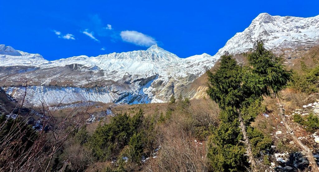
The unparalleled mountain panoramas accessible from the Pungyen plateau are consistently cited as the most dramatic views available on the entire Manaslu Circuit. Because the Gompa is situated directly at the base of Mount Manaslu, the plateau offers an unobstructed view of the mountain’s sweeping south and east faces. On clear, crisp Himalayan mornings, the proximity to the surrounding glacial moraines and the jagged peaks of the Ganesh Himal range to the east creates a visual theater that completely envelops the viewer. The sheer scale of the 8,163-meter peak looming directly overhead provides a humbling perspective on human insignificance in the face of geologic time.
Deep cultural immersion is guaranteed at Pungyen Gompa, as it serves as a repository of authentic Nubri and Tibetan-Buddhist culture. Trekkers are afforded the increasingly rare opportunity to observe daily monastic rituals, listen to the resonant frequencies of monks chanting in the main prayer halls, and witness the lighting of traditional butter lamps without the performative, transactional aspects found in heavily touristed areas like Kathmandu or the lower Khumbu valley. The authenticity of this interaction stems from the fact that the monastery exists entirely independent of the trekking economy; it is sustained by local devotion and historical precedent.
Crucial physiological acclimatization is perhaps the most pragmatic highlight of the excursion. The human body requires active cardiovascular stress at higher elevations to stimulate the production of oxygen-carrying red blood cells. By implementing the foundational mountaineering principle of “climb high, sleep low,” the rigorous ascent from Samagaon at 3,530 meters to the Gompa at 4,000 meters, followed by the descent back to Samagaon for the night, perfectly executes this physiological mandate. Trekkers who undertake this hike report significantly lower incidences of altitude-related headaches and fatigue during the subsequent push toward the 5,106-meter Larkya La Pass.
The historical resonance and resilience embedded in the Gompa’s stones add a profound layer of historical context to the physical landscape. The monastery’s dark yet powerful history—specifically its total destruction by a catastrophic glacial avalanche in 1953 and its subsequent rebuilding through an unprecedented collaboration between local villagers and international Japanese climbers—serves as a monument to community resilience. This history fundamentally altered the rules of engagement for mountaineering in the region, ensuring that modern expeditions must respect local theological boundaries.
Architectural authenticity defines the physical structures of the plateau. Pungyen Gompa is a prime, unadulterated example of traditional Tibetan-style Buddhist architecture. The complex features intricate, hand-carved woodwork, vibrant interior murals depicting Buddha Shakyamuni and Guru Rinpoche (Padmasambhava), and classic whitewashed cylindrical chortens (stupas) that stand in stark defiance of the harsh alpine elements. Because the structures are built from local mud, stone, and timber, they appear as a natural, organic extension of the mountain itself.
Encounters with high-altitude ecology become immediately apparent as trekkers navigate the steep trail leading up from Samagaon. The route weaves through diverse flora and fauna that transition rapidly due to the sharp elevation gradient. Trekkers frequently encounter massive herds of grazing yaks utilizing the alpine turf, navigate through fields of hardy alpine shrubs, and observe rare avian species such as the massive lammergeier (bearded vulture) wheeling effortlessly on the thermal updrafts generated by the valley walls.
Finally, the solitude and serenity of the Pungyen Gompa plateau provide a sharp contrast to the physical exertion required to reach it. Because a large percentage of trekkers bypass the Gompa in favor of shorter, less demanding side trips like Birendra Lake, the plateau remains remarkably quiet and undisturbed. This isolation provides an acoustically clean environment that is highly conducive to introspection, undisturbed photography, and deep, restorative rest before the most challenging days of the circuit.
What to expect
Anticipating the physical, meteorological, and psychological realities of the Pungyen Gompa detour is vital for thorough trek preparation. Ignorance of high-altitude variables can quickly transform a spiritual excursion into a logistical crisis. Trekkers venturing onto this path should expect the following five foundational realities.
| Expectation Category | Practical Implication | Required Preparation |
| A Demanding Physical Ascent | Steep, uneven terrain causing rapid cardiovascular fatigue. | High-quality trekking boots, trekking poles, and adherence to a slow, methodical pace. |
| A “Living” Spiritual Sanctuary | Monks engaged in private devotion; basic, unpolished infrastructure. | Modest dress, respectful silence, and permission required before taking photographs. |
| Rapid Meteorological Shifts | Plunging temperatures, sudden cloud cover, and high winds. | Comprehensive layering system including windproof shells and heavy down insulation. |
| Minimal Infrastructure | Complete absence of teahouses, cafes, or reliable cellular networks. | Total self-sufficiency regarding hydration (2L minimum), high-calorie snacks, and medical kits. |
| Profound Silence | An extreme lack of mechanical or urban noise pollution. | Mental readiness for isolation and introspective psychological experiences. |
A demanding physical ascent is the absolute prerequisite for experiencing the Gompa. The route is not a casual, flatland stroll. While the total round-trip distance is approximately 14.5 to 15 kilometers, the terrain transitions violently from dirt paths to steep, rocky moraines and highly exposed alpine grasslands. The first hour and a half of the ascent out of the Samagaon valley involves a rigorous uphill gradient that will severely test lung capacity and muscular endurance in the increasingly thin air. The lack of oxygen at 4,000 meters means that even highly fit individuals must adopt a deliberate, methodical pace to avoid exhaustion.
A “living” spiritual sanctuary dictates the behavioral parameters of the visit. Upon arrival, visitors will not find a museum, a gift shop, or a polished tourist attraction. Pungyen Gompa is built from raw stone, mud, and timber. The structures are inherently rudimentary, and the resident monks and nuns are deeply focused on their lifelong spiritual practices. Trekkers should expect an atmosphere of intense solemnity. Silent observation is preferred over intrusive interaction. It is expected that visitors will remove their shoes before entering the main prayer halls, dress modestly despite the physical exertion of the hike, and explicitly ask for permission before aiming cameras at the residents or the sacred murals.
Rapid meteorological shifts are a defining characteristic of the 4,000-meter microclimate. The weather dynamics at the base of an 8,163-meter peak are notoriously volatile. A morning that begins with crystal-clear blue skies and strong, warming solar radiation can rapidly deteriorate into a whiteout of localized clouds, biting glacial winds, or sudden snowfall by early afternoon. This volatility necessitates an adaptable, comprehensive multi-layered clothing strategy. Trekkers must carry waterproof hardshells, heavy down jackets, and insulated gloves in their daypacks, even if they begin the hike in a light t-shirt.
Minimal infrastructure is a logistical reality that demands total self-sufficiency. There are absolutely no commercial teahouses, cafes, emergency shelters, or mobile network towers (save for highly intermittent NTC coverage) at the monastery itself. The detour requires trekkers to carry everything they will need for the duration of the 6 to 7-hour round trip. This includes a minimum of two liters of purified water per person, high-calorie snacks to replenish glycogen stores, and a comprehensive emergency medical kit containing blister treatments, ibuprofen, and altitude sickness medication (Diamox).
Profound silence defines the acoustic environment of the plateau. Away from the main trekking thoroughfare of the Manaslu Circuit and the agricultural activity of Samagaon, the auditory environment changes drastically. The mechanical noises of the lower valleys are replaced entirely by the organic soundscape of the high Himalayas: the howling of glacial winds, the rhythmic flapping of prayer flags, the distant, thunderous cracking of avalanches on the higher, inaccessible slopes of Manaslu, and the low, resonant chanting of the monks. This extreme acoustic purity fosters an environment that strips away psychological distractions and demands total mindfulness.
Pungyen Gompa: Where Ancient Buddhism Meets the Majesty of Manaslu
To fully comprehend the immense significance of Pungyen Gompa, one must look far beyond its scenic geographic location and delve into the complex intersection of regional anthropology, deep religious devotion, and the geopolitical history of mid-20th-century mountaineering. The monastery is a physical manifestation of the fraught relationship between human ambition and the reverence for the natural world.
The nomenclature of the site is deeply tied to the topography. The name “Pungyen” is derived directly from “Pungyen Himal,” the indigenous Tibetan terminology for Mount Manaslu, the towering peak that dominates the visual and climatic landscape of the entire region. For the ethnic Nubri and Tsum populations that migrated from Tibet and settled in these high valleys over 400 years ago, the mountain is not merely a geological formation of rock and ice. It is universally revered as the physical embodiment of Lord Pungyen, a powerful, volatile guardian deity believed to preside over and protect the Manaslu, Himal Chuli, and Ganesh Himal ranges. Around 1600 CE, these early settlers constructed a rudimentary stone hermitage on the exposed plateau to honor this deity. This established a spiritual sanctuary that served multiple practical and theological functions: caravan traders journeying from Tibet utilized it as a safe bunking site, ascetic monks sought profound isolation in the adjacent cliffside caves, and local yak herders regularly left offerings of precious butter to ensure the safety of their livestock in the treacherous pastures.
The intersection of this localized, ancient spirituality and the aggressive expansion of international mountaineering came to a devastating and violent head in the mid-20th century. Following the opening of Nepal’s previously sealed borders to foreign expeditions in 1950, international climbers rushed to conquer the 8,000-meter peaks. A Japanese reconnaissance team arrived at the base of Manaslu in 1952 but was immediately met with fierce local opposition driven by deeply held spiritual concerns regarding the violation of the deity’s domain. In May 1953, during a subsequent Japanese expedition attempt, the catastrophic reality of high-altitude physics intervened. A massive serac (a block of glacial ice) collapsed from the upper, unstable slopes of Manaslu, triggering a monumental avalanche that swept down the mountain and completely buried the ancient Pungyen Gompa. The disaster claimed the lives of 18 local villagers and resident monks, obliterating centuries of architectural history in seconds.
The indigenous survivors interpreted this tragedy strictly through a theological lens. In their view, the intrusion of the foreign climbers had deeply angered Lord Pungyen, and the avalanche was an act of direct divine retribution. Consequently, when a highly funded Japanese team returned in 1954 to attempt the summit once again, they were confronted at the Samagaon base camp by enraged, grieving villagers. The locals, wielding stones and traditional khukuris (curved Nepalese knives), formed a hostile blockade, forcing the climbers to abandon their Manaslu objective and retreat in defeat to the adjacent Ganesh Himal region.
This historical friction necessitated a permanent, diplomatic shift in the power dynamics of Himalayan mountaineering in the region. Following intense diplomatic interventions and substantial financial contributions from the Japanese climbing community to fund the complete rebuilding of the monastery between 1954 and 1957, a strict, uncompromising local mandate was established. To this day, no mountaineering expedition is permitted to scale Mount Manaslu without first participating in a localized religious ceremony to receive the blessing of the head lama. This blessing is physically symbolized by the bestowal of a red wool wrist cord (khatag) to every climber.
The Pungyen Gompa that stands today is the meticulously reconstructed iteration of the original site. It serves as a monument not only to Buddhist faith but to community resilience and the necessary, forced synchronization of human exploratory ambition with the reverence for nature. The physical structure of the rebuilt Gompa reflects classical Tibetan-Buddhist architectural paradigms. The complex is framed by a diminutive stone portal that leads into the sacred courtyard, characterized by multi-tiered roofs adorned with decorative finials and a striking yellow-painted pinnacle. The main prayer hall, known formally as the Du-khang, is painted in rich, earthy ochres and deep reds. Its interior is spiritually anchored by a massive, three-meter-high gilt-bronze statue of Buddha Shakyamuni, which is symmetrically flanked by effigies of Avalokiteshvara (the Bodhisattva of Compassion) and Guru Rinpoche (Padmasambhava). Just below the main Gompa stand a series of whitewashed cylindrical chortens, where devotees endlessly spin prayer wheels, generating merit that is carried across the plateau by the glacial winds. The rear of the complex contains the simple, unheated stone-and-timber quarters for the resident monastics, who endure the freezing temperatures to maintain the continuous cycle of prayer.
Why trek with Alpine Vista Treks
Navigating a highly restricted, high-altitude environment like the Manaslu Circuit requires impeccable logistical planning, advanced risk management protocols, and a deep, nuanced understanding of local socio-cultural dynamics. Alpine Vista Treks, a fully government-registered adventure and trekking agency based in Kathmandu, has deliberately positioned itself as a premier, ethical facilitator for this exact type of specialized, high-stakes journey.
The rationale for selecting Alpine Vista Treks for the 2026 trekking season rests on several fundamental operational pillars that distinguish them from volume-driven, budget operators. Foremost is their absolute mastery of regulatory compliance and permitting. The Manaslu region operates under strict, heavily monitored government oversight. Alpine Vista Treks seamlessly handles the highly complex, bureaucratic procurement of the Manaslu Restricted Area Permit (MRAP), the Manaslu Conservation Area Permit (MCAP), the Annapurna Conservation Area Permit (ACAP), and all required local municipality fees. By ensuring all electronic paperwork and governmental clearances are flawless prior to the trekker’s arrival in Nepal, they eliminate the risk of delays at the numerous police checkpoints scattered along the Budhi Gandaki gorge.
Furthermore, the agency exclusively employs elite, government-licensed mountain guides who possess decades of combined experience operating specifically in the Manaslu and Tsum Valley sectors. These guides act as much more than mere pathfinders; they serve as vital cultural liaisons, safety officers, and expert navigators capable of reading the shifting, dangerous terrain caused by frequent summer landslides and unpredictable seasonal snowfalls. Their localized knowledge allows trekkers to engage meaningfully with the residents of Samagaon and the monks at Pungyen Gompa, translating complex cultural nuances that would otherwise remain opaque to foreigners.
Safety protocols are deeply integrated into every Alpine Vista Treks itinerary. The agency utilizes advanced high-altitude safety management systems, outfitting their lead guides with satellite communication grids to ensure connectivity in the numerous cellular dead zones along the circuit. They have established rapid emergency evacuation protocols, which is a critical necessity when traversing isolated, high-risk segments like the Larkya La Pass or the exposed Pungyen Gompa plateau.
Ethically, the company operates under a strict eco-tourism and community-first mandate. Alpine Vista Treks ensures fair, legal wages and comprehensive insurance coverage for all its guides and porters. This ethical framework fosters a sustainable economic model that directly benefits the localized, marginalized economies of the Nubri and Tsum valleys, ensuring that tourism dollars actively support the communities that maintain the trails and the cultural sites. Finally, their logistical synchronization is unparalleled. From coordinating private 4WD transportation from the chaotic streets of Kathmandu to the rugged trailhead at Machha Khola, to vetting and securing highly scarce teahouse accommodations in upper bottleneck villages like Dharamsala, Alpine Vista Treks completely insulates the trekker from logistical friction, allowing them to focus entirely on the physical and spiritual experience of the Himalayas.
Pungyen Gompa: The Perfect Place for Yoga, Meditation, and Inner Peace
The extreme physiological strain of high-altitude trekking frequently induces a state of heightened psychological clarity, forcibly stripping away the mental clutter, anxiety, and digital dependency of modern urban life. Pungyen Gompa actively capitalizes on this biological and psychological phenomenon, serving as a globally unparalleled environment for yoga, deep meditation, and profound spiritual recalibration.
For centuries, Tibetan Buddhist monks have actively sought out such isolated, extreme environments precisely because the sheer harshness of the natural world forces an intense internal focus. The original hermitage at Pungyen was explicitly founded as an ascetic retreat where dedicated practitioners could meditate in the adjacent cliffside caves for months or years at a time, entirely removed from the agricultural and social distractions of the lower villages. Today, modern trekkers who visit the site can directly partake in this enduring legacy. The sensory input at 4,000 meters is incredibly potent: the rhythmic, percussive fluttering of colorful prayer flags carrying holy mantras on the biting wind, the low, hypnotic hum of monks chanting in unison, and the crisp, aggressively thin air create an acoustic and atmospheric backdrop that is perfectly tuned for mindfulness.
Furthermore, the Gompa remains a vibrant epicenter for elaborate religious festivals that draw localized devotees from across the high valleys, temporarily transforming the silent plateau into a theater of color and sound. During critical calendrical events such as Lhosar (the Tibetan New Year) and Mani Rimdu (an exhaustive 19-day celebration strictly dedicated to Guru Rinpoche Padmasambhava, the founder of Tibetan Buddhism), the Gompa’s courtyard comes alive. These festivals feature highly complex, ceremonial mask dancing, the rhythmic, trance-inducing beating of the dhyangro (traditional shamanic drum), esoteric rituals, and massive communal feasts. Visitors fortunate enough to be present during these periods are afforded an extraordinary opportunity for cultural exchange, observing firsthand how rigorous meditation and joyous, chaotic celebration seamlessly coexist within the Tibetan Buddhist framework.
However, even on ordinary, non-festival days, the spiritual utility of the site remains immense. Trekkers are warmly welcomed to participate in the atmosphere of devotion. Visitors can remove their boots, dress modestly to respect the sanctity of the space, and sit silently within the main prayer hall, participating in a shared, profound silence that transcends any language barrier. Whether performing a quiet yoga sequence facing the immense glaciers of Manaslu or simply sitting in seated meditation while observing the monks light hundreds of butter lamps, the experience at Pungyen Gompa inevitably leads to a deep sense of inner peace and a recalibration of personal perspective.
How to reach there
The excursion to Pungyen Gompa is executed as a rigorous, full-day acclimatization hike, utilizing the major cultural hub of Samagaon (3,530 meters) as the logistical base camp. The navigation logic required to reach the Gompa demands a keen understanding of the local trails and topography, as official signboards are exceedingly rare in this restricted zone.
The physical journey begins after breakfast by backtracking slightly along the main Manaslu trekking trail, heading back toward the lower village of Shyala. The critical diversion point for the monastery occurs near a highly specific local landmark: the Shree Gaurishankar Basic School. Upon reaching the school, the route branches off sharply, transitioning from the relatively flat main trail onto a steep, zigzagging, stone-paved path that immediately begins ascending the valley walls toward the hidden plateau.
As trekkers climb this demanding gradient, the topography undergoes a rapid and highly visible ecological shift. The protective, oxygen-rich pine and rhododendron forests that characterize the lower elevations gradually thin out and recede entirely, giving way to steep, highly exposed alpine grasslands, tiny, wind-battered bushes, and massive, rocky glacial moraines left behind by retreating ice. The trail becomes steeper, narrower, and significantly more exposed to the elements. Approximately one hour before reaching the final destination, trekkers pass through a ceremonial lower monastery gate, continuing along a narrow, windswept path characterized by sparse high-altitude vegetation until the main complex suddenly reveals itself against the backdrop of the mountain.
The total round-trip distance from Samagaon to the Gompa and back is substantial, measuring approximately 14.5 to 15 kilometers (roughly 9.16 miles). The arduous ascent, which gains approximately 470 vertical meters of elevation from the valley floor to the 4,000-meter plateau, generally takes 3 to 4 hours of continuous hiking. This slow pace is strictly dictated by the thinning oxygen levels, which heavily tax the cardiovascular system. The return journey, which follows the exact same route, involves a steep, knee-testing downhill descent that requires 2 to 3 hours to navigate safely. In total, it is a demanding 6 to 7-hour endeavor that fully occupies the designated acclimatization day in Samagaon, ensuring trekkers are physically primed for the higher altitudes to come.
Itinerary
A meticulously structured itinerary is the absolute backbone of safe high-altitude trekking. The following 12-day framework, actively utilized and perfected by expert agencies like Alpine Vista Treks, optimizes acclimatization scheduling, ensuring that the human body adapts naturally to the extreme elevations prior to the final, hypoxic pass crossing.
Recommended 12-Day Manaslu Circuit Trek Itinerary
| Day | Route | Altitude | Distance |
|---|
| Day 1 | Kathmandu to Machha Khola (Drive) | 930m | 160 km Drive |
| Day 2 | Machha Khola to Jagat | 1,410m | 22 km |
| Day 3 | Jagat to Deng | 1,800m | 19 km |
| Day 4 | Deng to Namrung | 2,630m | 20 km |
| Day 5 | Namrung to Shyala | 3,520m | 16 km |
| Day 6 | Shyala to Samagaun | 3,520m | 8 km |
| Day 7 | Acclimatization Day (Manaslu Base Camp or Birendra Lake Hike) | 3,520m | 8–12 km (Optional Hike) |
| Day 8 | Samagaun to Samdo | 3,860m | 8 km |
| Day 9 | Samdo to Dharamsala (Larke Phedi) | 4,460m | 11 km |
| Day 10 | Dharamsala – Larkya La Pass (5,106m) – Bimthang | 3,750m | 16 km |
| Day 11 | Bimthang to Tilje | 2,300m | 19 km |
| Day 12 | Tilje to Besisahar by Local Jeep, then Drive to Kathmandu or Pokhara | 1,400m (Kathmandu) / 822m (Pokhara) | 170 km to Kathmandu / 105 |
Detailed 12-Day Manaslu Circuit Trek Itinerary
Day 1: Kathmandu to Machha Khola (869m)
Distance: 160 km Drive
Driving Time: 7–9 Hours
A long, punishing 4WD drive (8-10 hours) transports trekkers from the congested Kathmandu Valley, winding through the middle hills via Soti Khola. The vehicle closely follows the deep, narrow gorge of the Budhi Gandaki River to the new, continually expanding motorized trailhead at Machha Khola.
Day 2: Trek from Machha Khola to Jagat (1,340m)
Distance: 22 km
Walking Time: 6–7 Hours
The physical trekking officially begins with a massive 22-kilometer day. The trail weaves back and forth across thrilling, swaying suspension bridges over the raging Budhi Gandaki. The environment is highly subtropical, featuring terraced agriculture and waterfalls, before reaching Jagat, a beautiful flagstone-paved village that serves as the official, heavily guarded entry checkpoint for the restricted Manaslu Conservation Area.
Day 3: Trek from Jagat to Deng (1,860m)
Distance: 19 km
Walking Time: 6–7 Hours
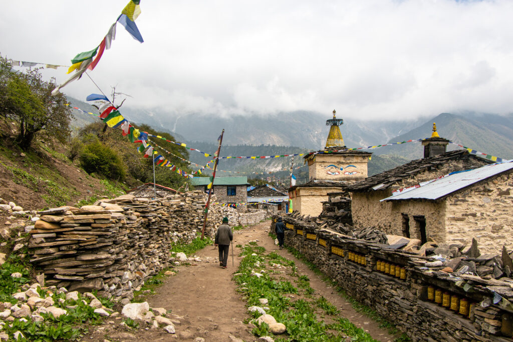
A 6 to 7-hour hike covering nearly 20 kilometers. The valley narrows significantly into steep, claustrophobic canyon walls. As the trail ascends, the cultural landscape begins its definitive shift; the Hindu architecture and shrines of the lower regions are slowly replaced by Buddhist chortens and mani walls as the trail approaches the small settlement of Deng.
Day 4: Trek from Deng to Namrung (2,630m)
Distance: 20 km
Walking Time: 6–7 Hours
This is a vital physiological transition day where the effects of altitude begin to factor heavily into daily pacing. The 19.5-kilometer hike ascends sharply through dense, temperate alpine forests of pine and rhododendron. The first truly clear, unobstructed views of the surrounding high snow peaks become visible upon arrival at the prominent village of Namrung, marking the entry into the upper Nubri valley.
Day 5: Trek from Namrung to Shyala (3,520m)
Distance: 16 km
Walking Time: 6–7 Hours
This is one of the most scenic days of the trek. The route passes through Lihi, Sho, and Lho villages, offering breathtaking views of Mount Manaslu, Himal Chuli, and Ngadi Chuli. You will visit ancient monasteries, colorful prayer flags, and traditional Tibetan-style settlements. Upon reaching Shyala, you are surrounded by towering Himalayan peaks on all sides, making it one of the most picturesque locations on the entire circuit.
Day 6: Trek from Shyala to Samagaun (3,520m)
Distance: 8 km
Walking Time: 3–4 Hours
A relatively short and easy trekking day allows your body to adjust to the increasing altitude. The trail traverses alpine landscapes and yak grazing pastures before arriving at Samagaun, the largest village in the upper Manaslu region. This traditional Tibetan settlement sits directly beneath Mount Manaslu and serves as the main acclimatization stop for trekkers. Spend the afternoon exploring the village, local monasteries, and surrounding scenery.
Day 7: Acclimatization Day at Samagaun (3,520m)
Optional Hiking Distance: 8–12 km
Walking Time: 4–7 Hours
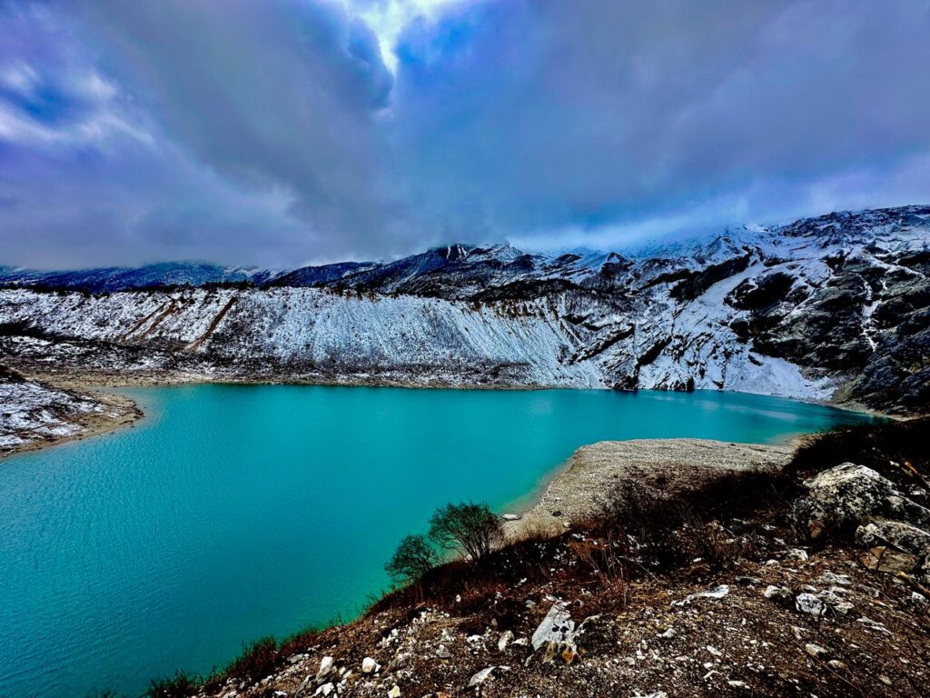
Acclimatization is crucial for a successful crossing of Larkya La Pass. Today you can choose between several rewarding side hikes. A popular option is a visit to Birendra Lake, a beautiful glacial lake beneath the Manaslu Glacier. Stronger trekkers may continue to Manaslu Base Camp at approximately 4,800 meters for incredible close-up views of Mount Manaslu and the surrounding glaciers. After the excursion, return to Samagaun for overnight accommodation.
Day 8: Trek from Samagaun to Samdo (3,860m)
Distance: 8 km
Walking Time: 3–4 Hours
Today’s trail gradually climbs through open alpine terrain with stunning mountain scenery. The landscape becomes increasingly barren as you approach the high Himalayan environment. Samdo is a traditional Tibetan refugee village located close to the Tibetan border. The village offers incredible panoramic views of surrounding peaks and serves as another important acclimatization point before crossing the pass.
Day 9: Trek from Samdo to Dharamsala (Larke Phedi) (4,460m)
Distance: 11 km
Walking Time: 4–5 Hours
The route continues along rugged mountain terrain with spectacular views of glaciers and snow-capped peaks. Crossing several streams and moraines, you eventually reach Dharamsala, also known as Larke Phedi. This small settlement serves as the final stop before crossing Larkya La Pass. The altitude is significant, so rest, hydrate well, and prepare your gear for the challenging day ahead.
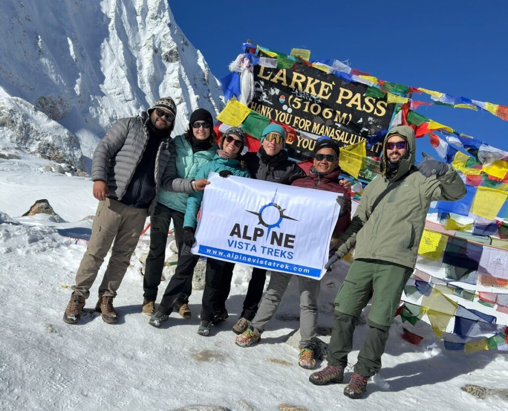
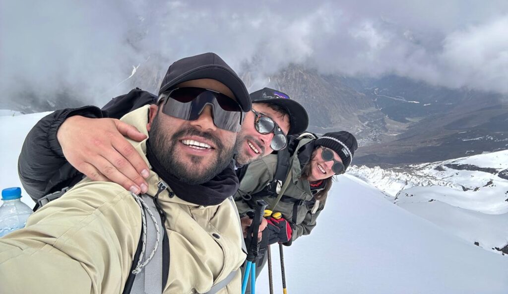
Day 10: Cross Larkya La Pass (5,106m) and Trek to Bimthang (3,750m)
Distance: 16 km
Walking Time: 7–9 Hours
This is the highlight and most demanding day of the trek. You begin before sunrise and gradually ascend toward Larkya La Pass, the highest point of the Manaslu Circuit at 5,106 meters. The climb is challenging but rewards trekkers with breathtaking panoramic views of Himlung Himal, Cheo Himal, Kang Guru, Annapurna II, and countless snow-covered peaks. After celebrating at the summit, you descend through glacial valleys and rugged terrain to reach the beautiful meadow settlement of Bimthang. Overnight at a teahouse.
Day 11: Trek from Bimthang to Tilje (2,300m)
Distance: 19 km
Walking Time: 6–7 Hours
Leaving the high alpine environment behind, the trail descends through rhododendron forests, pine woodlands, and traditional villages. As the altitude decreases, the air becomes noticeably richer in oxygen and temperatures become warmer. You pass through Yak Kharka and Gho before arriving at Tilje, a charming village known for its traditional stone houses and welcoming local culture.
Day 12: Drive from Tilje to Besisahar and Continue to Kathmandu or Pokhara
Distance: Approximately 170 km to Kathmandu / 105 km to Pokhara
Driving Time: 7–9 Hours to Kathmandu / 5–6 Hours to Pokhara
Your final day begins with a local jeep ride from Tilje to Besisahar along a rough mountain road. From Besisahar, you transfer to a private vehicle or tourist bus for the journey back to Kathmandu or Pokhara. As you leave the mountains behind, you can reflect on an incredible adventure through one of Nepal’s most spectacular trekking regions. The Manaslu Circuit offers a perfect combination of Himalayan scenery, authentic culture, remote wilderness, and personal achievement that few treks in the world can match.
Food and accommodation
Trekking the Manaslu Circuit is strictly categorized as a “teahouse trek,” meaning that daily logistics revolve entirely around a network of family-run mountain lodges rather than self-supported, heavy expedition camping. However, due to the region’s extreme remoteness and total lack of road infrastructure in the upper valleys, the standard of food and accommodation fluctuates drastically and inversely corresponding to altitude.
Accommodation Realities
In the lower and mid-elevations (from Machha Khola up to Namrung), the teahouse infrastructure has seen significant capital improvements by the 2026 season. Trekkers can reliably expect clean, twin-sharing rooms, highly functional communal dining halls heated by cast-iron wood or yak-dung stoves, and occasionally attached bathrooms featuring solar-heated showers.
However, as the trail relentlessly ascends past Samagaon into the harsh environments of Samdo and Dharamsala, facilities revert to the absolute, unforgiving basics. Rooms at these elevations are entirely uninsulated plywood or stone cells, featuring only a simple wooden bed, a thin foam mattress, a pillow, and a heavily used blanket. The extreme nocturnal cold necessitates a high-quality, 4-season sleeping bag (rated to at least -15°C) to prevent hypothermia. At Dharamsala in particular, due to the high volume of peak-season trekkers converging on a limited number of beds, conditions are stark, and electricity is severely limited to a few solar panels. Modern amenities that were cheap lower down—such as hot bucket showers, device charging for phones and cameras, and slow satellite Wi-Fi—shift from being complimentary to costing a high premium (approximately $3 to $5 USD per service) due to the sheer logistical cost of generating power at 4,460 meters.
Dietary Strategy and Supply Chain Economics
Nutrition at high altitude must prioritize highly digestible, calorie-dense carbohydrates to aggressively fuel muscular exertion under severe hypoxic conditions. The absolute staple of the Himalayan trekking diet is Dal Bhat (a massive platter of steamed rice, lentil soup, and seasonal vegetable curries). This dish is renowned for its immense caloric density and the cultural standard of unlimited refills, making it the most economically efficient way to sustain energy.
In the lower regions, menus are surprisingly extensive and diverse, featuring fresh local produce, eggs, chicken, and numerous variations of noodles, pancakes, and fried rice. However, beyond Samagaon, the supply chain is heavily restricted by the total lack of road access; every single grain of rice must be carried up by mule trains or human porters. Consequently, fresh meat becomes an extreme rarity (and is best avoided entirely due to the total lack of refrigeration and risk of foodborne illness), and the diet simplifies drastically to dried goods, locally grown potatoes, root vegetables, oat porridge, thick Tibetan bread, and instant noodle soups. Maintaining hydration is paramount to stave off AMS; trekkers are strictly advised to consume copious amounts of hot liquids—such as ginger tea, hot lemon, and traditional, calorie-rich yak butter tea—and to utilize Lifestraws or chemical purification tablets rather than purchasing ecologically devastating, expensive single-use plastic bottles.
Transportation
The transportation network anchoring the Manaslu Circuit is universally characterized by its extreme roughness and high susceptibility to seasonal, weather-induced disruptions. Unlike the heavily commercialized Everest region, which relies entirely on the treacherous Lukla flight, Manaslu relies exclusively on overland access.
The official starting point of the trek has pushed progressively further up the Budhi Gandaki valley over the last decade due to relentless road construction, with Machha Khola now serving as the primary, accepted trailhead. The overland journey from Kathmandu to Machha Khola covers approximately 160 kilometers, but due to the deplorable state of the unpaved mountain tracks, it requires a grueling 8 to 10 hours of transit. While budget-conscious, highly adventurous trekkers can utilize dangerously crowded local buses (costing roughly $15 USD), the preferred, significantly safer, and far more reliable method utilized by premium operators like Alpine Vista Treks is private 4WD jeeps. These private vehicles, which cost between $120 and $280 USD per vehicle depending on demand, offer a modicum of comfort and the ability to navigate deep mud and minor landslides that routinely trap buses.
The exit strategy follows a remarkably similar, rugged pattern. Upon arriving in the town of Dharapani, the foot trail violently converges with a heavily trafficked, dusty jeep track. From here, trekkers must take shared or private 4WD vehicles down a notoriously terrifying, cliffside dirt road to the regional transport hub of Besisahar. From Besisahar, paved, relatively stable highways eventually lead back to the international airports in Kathmandu or Pokhara.

Guide and porter
In the specific operational context of the Manaslu Circuit, licensed guides and porters are not optional luxury additions for affluent tourists; they are strict legal requirements and fundamental structural necessities for survival.
Legal Framework and the 2026 Context
The Manaslu region’s status as a restricted conservation area bordering the politically sensitive region of Tibet mandates exceptionally strict government oversight. Previously, a minimum of two foreign trekkers was strictly required to obtain a permit, frustrating independent travelers. As of a recent, highly anticipated policy update enacted for the 2026 season, solo trekkers are now legally permitted to secure the Manaslu Restricted Area Permit (MRAP). However, the primary caveat remains completely inflexible: all trekkers, regardless of group size, must be physically accompanied by a government-licensed guide at all times, and the permits must be processed exclusively through a registered Nepalese trekking agency. Independent, unguided trekking is illegal, heavily fined, and heavily policed on this circuit.
Economic Structure and Ethical Standards
The financial cost of hiring local staff reflects their immense expertise and the severe physical toll the environment exacts upon them. For the 2026 season, the standard daily wage for a fully licensed, English-speaking guide ranges between $30 and $40 USD, while porters command between $20 and $30 USD daily. These daily fees generally encompass the staff’s wages, food, and teahouse accommodation. Reputable agencies, such as Alpine Vista Treks, explicitly add a surcharge to ensure comprehensive medical and helicopter rescue insurance coverage for their entire crew—a non-negotiable ethical standard when operating in high-altitude terrain prone to avalanches and sudden blizzards.
The Immense Value Proposition
A licensed guide provides value that far exceeds simple pathfinding. They serve as critical, highly nuanced cultural translators, granting trekkers meaningful, respectful access into active religious sites like Pungyen Gompa that might otherwise remain opaque or off-limits. More crucially, they expertly manage daily pacing to prevent altitude sickness, aggressively negotiate teahouse bed availability during the chaotic peak seasons, and expertly navigate the hazardous, ever-shifting landslide zones of the lower Budhi Gandaki gorge where the trail is frequently wiped out overnight. Porters, who regularly carry up to 20-25 kg of gear utilizing traditional head-straps (nampas), alleviate the immense physical burden on the trekker, making the grueling crossing of Larkya La achievable for individuals who are not professional mountaineers.
Permit and fees
The permit bureaucracy designed for the Manaslu Circuit is intentionally intricate, designed both to strictly monitor geopolitical border activity and to generate necessary funding for conservation efforts within the highly fragile alpine ecosystems. Trekkers are legally subject to four distinct, non-negotiable documentary requirements, which are aggressively checked at heavily armed police checkpoints throughout the trek.
| Permit Type | Autumn Season Cost (Sep – Nov) | Winter/Spring/Summer Cost (Dec – Aug) | Regulatory Purpose |
| Manaslu Restricted Area Permit (MRAP) | $100 for the first 7 days, plus $15 per additional day. | $75 for the first 7 days, plus $10 per additional day. | Border security and strict regulation of foot traffic in sensitive zones. Cannot be issued to independent trekkers. |
| Manaslu Conservation Area Permit (MCAP) | $30 USD (NPR 3,000) flat fee. | $30 USD (NPR 3,000) flat fee. | Direct funding for environmental protection and local community support initiatives. |
| Annapurna Conservation Area Permit (ACAP) | $30 USD (NPR 3,000) flat fee. | $30 USD (NPR 3,000) flat fee. | Legally required because the trail physically exits through Dharapani, crossing into the Annapurna jurisdictional zone. |
| Chumnubri Rural Municipality Fee | $7.50 to $15 USD (NPR 1,000 to NPR 2,000). | $7.50 to $15 USD (NPR 1,000 to NPR 2,000). | Direct financial injection mandated to fund local municipal infrastructure, schools, and trail maintenance. |
The commonly known Trekkers’ Information Management System (TIMS) card, which is mandatory for almost all other treks in Nepal, is generally superseded by the more rigorous MRAP while inside the restricted zone, eliminating the need to purchase both. A standard 12-day trek operated in the peak Autumn season typically yields a total, unavoidable permit cost of approximately $218 to $238 USD per person, entirely dependent on how many days are spent inside the restricted zone before crossing the pass.
Other side trips
While Pungyen Gompa represents the premier cultural and historical detour accessible from Samagaon, the mandatory acclimatization day offers two other highly prominent geographic alternatives. Understanding the extreme physiological distinctions between these options is vital for overall energy management prior to crossing Larkya La.
| Side Trip Option | Elevation | Elevation Gain (from Samagaon) | Round Trip Duration | Difficulty Level | Primary Appeal |
| Birendra Tal (Lake) | 3,691m | ~160m | 3 – 4 hours | Easy to Moderate | Scenic glacial reflections, low physical exertion, high reward. |
| Pungyen Gompa | 4,000m | ~470m | 6 – 7 hours | Moderate to Demanding | Unmatched cultural immersion, history, and moderate altitude stimulation. |
| Manaslu Base Camp (MBC) | 4,800m | ~1,270m | 6 – 7 hours | Highly Demanding | Extreme proximity to glaciers, high-altitude mountaineering culture, massive physiological strain. |
Birendra Tal is an emerald, incredibly pristine glacial body of water fed directly by the melting ice of the Manaslu Glacier. It requires only a short, manageable 3 to 4-hour round trip from Samagaon, with a highly forgiving elevation gain of approximately 160 meters. The lake offers ethereal, mirror-like reflections of the surrounding peaks and requires minimal physical exertion. It is the optimal, conservative choice for trekkers who are currently experiencing mild altitude fatigue and need to adhere strictly to light, active recovery.
Conversely, Manaslu Base Camp (MBC) is a severe physical test. Located at a punishing 4,800 meters, MBC serves as the staging ground and launching pad for commercial mountaineering expeditions seeking the summit. The hike requires a grueling 6 to 7-hour round trip covering 12 kilometers with a massive, unrelenting elevation gain of roughly 1,270 vertical meters from Samagaon. While the trail offers extreme, dangerous proximity to the mountain’s seracs and a fascinating glimpse into expedition life, it is physically draining. Trekkers should only attempt MBC if they have zero symptoms of altitude sickness and possess exceptional cardiovascular conditioning; otherwise, they risk totally jeopardizing their energy reserves for the impending Larkya La Pass.
The Pungyen Gompa detour represents the perfect, balanced synthesis. It offers a significantly more substantial acclimatization stimulus than Birendra Lake, but it actively avoids the exhaustive, dangerous muscular depletion of the Base Camp push, all while delivering a profound cultural narrative that neither of the purely geographical sites can possibly provide.
Conclusion
The Manaslu Circuit is frequently and rightfully lauded by the global trekking community for its raw, unforgiving physical beauty, its thrilling, precarious suspension bridges, and the ultimate, exhausting triumph of crossing the 5,106-meter Larkya La Pass. However, the true, enduring depth of the trek lies in its unique capacity to act as a physical corridor through time, leading trekkers deep into high-altitude enclaves where centuries-old traditions remain functionally intact and largely immune to the homogenizing forces of global tourism.
The demanding detour to Pungyen Gompa serves as the absolute crucible of this cultural experience. It is a site where geology, theology, and the aggressive history of human exploration violently intersected during the tragic 1953 avalanche, and where human resilience and unyielding faith subsequently rebuilt a sanctuary out of the very stones that destroyed it. To stand on the freezing, windswept plateau beneath the crushing verticality of the Manaslu massif, listening to the rhythmic chants of resident monastics, is to experience the Himalayas not merely as a playground for athletic endurance, but as a deeply sacred, living geography.
For the 2026 trekking season, attempting the Manaslu Circuit requires meticulous, obsessive preparation, a thorough understanding of highly complex permitting structures, and a profound respect for both the lethal realities of altitude and the localized socio-cultural norms. By intentionally engaging with professional, community-oriented operators such as Alpine Vista Treks, travelers ensure that their passage through this restricted region is safe, ethically sound, and logistically flawless. Ultimately, those who dedicate their crucial rest day in Samagaon to ascending the steep, breathless moraines toward Pungyen Gompa are universally rewarded with the profound realization that the true summit of the Manaslu trek is not only a physical mountain pass, but a rare moment of profound, undisturbed inner peace.